| |
![]()
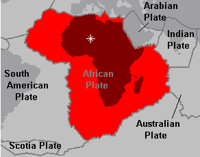
 African Plate
The African plate is approximately 1/2 land mass with a divergent plate boundary on the west edge running up through the Red Sea. The center of the plate is on land mass, but not in a good location. The African plate turns at a very slow counter-clockwise direction causing a lot of earth quake and volcanic activity on the west coast of Africa. The center of the plate would be too close to this area.
A better location having good elevation with less earth quake and volcanic activity, I would choose a city called Tamanrasset, located in the Ahagger Mountains in the northern part of the country in Algeria. The city of Tamanrasset is located at longitude 10 degrees west and latitude 20 degrees north, 2000 miles from the Red Sea to the east, 1400 miles from the west coast, 1000 miles from the Mediterranean Sea to the north and 1100 miles north of the nearest southern seas. Tamanrasset is at an elevation of 3000 feet, with varied elevations of zero to 9000 feet within a few hundred miles.
 | The local area shows no volcanic or earth quake activity. There is activity almost due north in and above the Mediterranean Sea near Europe 1500 miles to the north and in the mountains in Chad located 800 miles east. These seem to be the closest activity at the present time. This area should be fairly old land because of the rotation of the plate and most activity being on the east coast and then pushed west because of new land being formed. For future use, the country has petroleum deposits and the fourth largest natural gas reserves in the world. There are also deposits of iron ore, phosphates, mercury, and zinc. |
Offered by Clip.
