Plates on the Move
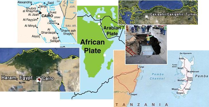
The 7 of 10 scenarios are all about plate movement. Where the big drama is in Indonesia and mountain building in the Andes,
plate movement is perceptible elsewhere and indicative of the 7 of 10 scenarios to come and in process. As the African Plate
starts to roll and drop, this would begin to separate the Straits of Gibraltar and stretch the distance between the Egyptian side
of the Red Sea from the Sinai. It would also start to roll the Arabian Plate, where the pointed top of this plate cuts from west
to east, stressing the Eurasian Plate above this slicing point. Is this happening? We find a sinkhole in Eskisehir, Turkey, where
sinkholes are virtually unknown. As the pointed top of the Arabian Plate moves from west to east, it would pull this area,
stretching it, the most common cause of sinkholes. Dropping to Cairo we find sinkholes also, not far from the river Nile.
Cairo also does not prone to sinkholes, but as the Red Sea pulls apart, this area would indeed be stretched and river bottoms
are a thin place on the plate, thus drooping to form a river bottom in the first place. Dropping further along the African Plate,
we arrive at Pemba, a tiny island just off the east coast of Africa. Pemba has a very low elevation, 50 meters the highest
point, but this would not account for the seawater now flooding homes and fields. Africa's Rift Valley widens as Africa rolls,
the whole southeastern side loosing its base as it does so, drooping. Pemba is just to the east of the Rift Valley.
- Road Crashed Car Disappeared
June 1, 2011
http://www.kanaldhaber.com.tr/Haber/Gundem-32/
- In Eskisehir a parked car fell into the pit with a depth of 3 meters as a result of the collapse of the road.
-
- 3 People Die Unexpectedly Landslides
June 04, 2011
http://vov.vn/Home/Ai-Cap-3-nguoi-chet-vi-sut-dat-bat-ngo/
- The cause of road subsidence is attributed to heavy rain occurred in recent years in Egypt. 3 passenger cars
are launched in the city of Mina Helwan to have fallen into deep sinkholes on the road Karim 3m, length 50 m.
Township Helwan, Egypt's capital Cairo.
-
- Pemba Gets a Whiff of Climate Change Hazards
June 2, 2011
http://dailynews.co.tz/home/?n=20359&cat=home
- Residents of Pemba Islands, particularly those farming and living along the Indian Ocean
have started to feel the pinch of climate change as seawater starts to flood their farms and houses.
ZetaTalk Prediction 10/16/2010: The roll will incite the Arabian Plate to roll also, to some degree, as across from
Egypt there will be pressure, but further down the Red Sea there will be a tearing apart, inviting the Arabian Plate to
migrate in this direction. However, this is not the disaster we have predicted for Iraq, not yet. Nor will the Afar
Triangle, the African Rift Valley, experience changes all that dramatic during this roll.
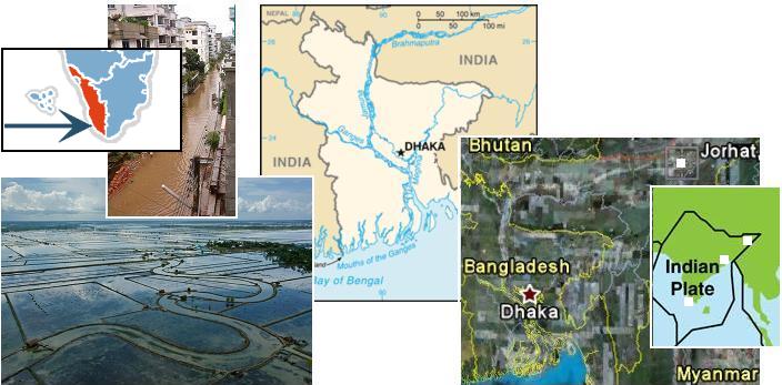
The Zetas have called the plunging of the Indo-Australian Plate the brake point holding all other plate movement back. As the
plate tips up at the New Zealand side, it plunges India under the Himalayas, allowing the Pacific to compress and the Sunda
Plate tongue holding Indonesia to plunge under the curve of the Indo-Australian Plate. Has the India side of the plate been
plunging? Bangledesh and Kuttanad on the tip of India are sinking, and in the eastern Himalayas, mountain building is taking
place, heaving river bottoms and preventing drainage. Suddenly, and with scant rain, Jorhat is under water!
- Building Dikes to Keep Low-Lying Farms from Being Flooded with Seawater
June 02, 2011
http://everybodysbusiness.org/tag/bangladesh/
- We look to Bangladesh, whose citizens are featured in the May 2011 issue of National Geographic as they
continue to persevere in a drastically changing landscape.
-
- Rain Wreaks Havoc in Kerala
June 5, 2011
http://www.deccanchronicle.com/channels/nation/south/
- In Kuttanad, more than 50 hectares of paddy farms are submerged in water. The disaster management cell is
also alert to the threat of sea surges in coastal areas.
-
- Many Parts of Jorhat Reeling Under Flash Floods
May 30, 2011
http://www.assamtribune.com/scripts/detailsnew.asp?id=may3111/state05
- A single shower last night has made a large portion of the Jorhat town reeling under artificial flood.
ZetaTalk Prediction 2001: Due to the compression of the Pacific during the forthcoming pole shift, India is forced
under the Himalayan highlands, with a violent thrust of the Indo-Australian plate. More than the country of India
and Bangladesh and Bhutan will be pushed under the Himalayas.
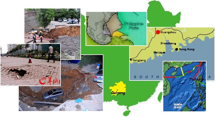
Moving east along the globe we find the line across the South China coastline, where the plate tongue holding Indonesia is
bent down to be pushed under the curve in the Indo-Australian Plate. Ground fractures when such a bend in the rock occurs.
Draw a line from where the Philippine Plate is being pushed against the coastline of China, west, and the line runs through
Guangzhou and City of Guiyang! The Philippine Plate is tilting, pushing under the Philippine Islands, as part of the
compression of the Pacific.
- Land subsidence in Zhujiang New City
June 2, 2011
http://www.cnkeyword.info/two-rounds-of-the-pearl-river
- Zhujiang New City, the road suddenly a pit trap.
-
- In City of Guiyang - Giant Sinkhole
June 4, 2011
http://www.epochtimes.ru/content/view/48421/4/
- In Guizhou Province on May 31 formed another failure, this time in a residential area of Guiyang city. Six
cars were trapped.
ZetaTalk Prediction 10/16/2010: The southern coast of China was likewise warned that they could experience loss of
elevation. How much will their coastline drop, that they needed this warning from the Hangzhou UFO? This
coastline, in general, can anticipate losing 20 feet in elevation
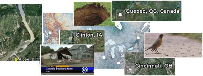
Moving further east to the Americas, where the N American continent is under a bow stress - the Aleutian Islands being
pulled toward the tip of Mexico which is tugging west. What does an earthworm plague in Cincinnati, a 100 year old house
suddenly dropping into a sinkhole in Clinton, Iowa, and sinkholes in Quebec have in common? All these spots are along
rivers! Earthworms will come to the surface to mate, and signal each other by a type of vibration called drumming. Rock
under stress also vibrates. Certainly for a house that has stood for 100 years to suddenly find its foundation infirm is suspect.
Ground movement is the likely culprit, and the Mississippi will be ripped open during the coming New Madrid adjustment,
and Cincinnati on the Ohio River will also be affected. Clearly, the Seaway is being pulled open, and to the west of this rip
we have British Columbia, where a landslide occurred at Hope. All of these seemingly unrelated incidents are related.
- Earthworm Plague Sweeps Cincinnati
June 4, 2011
http://www.msnbc.msn.com/id/43260807/ns/technology
- People across the Tri-State awoke to an unusual sight Thursday - thousands of earthworms lying dead on
sidewalks and porches.
-
- House Slides Into Sinkhole
June 3, 2011
http://www.ketv.com/r/28120353/detail.html
- A century-old home in Clinton has collapsed into a sinkhole.
-
- Ground Holes Prompt Evacuations in QC
May 28, 2011
http://www.cbc.ca/news/canada/montreal/story/2011/05/27/
- Engineers and geologists are examining dozens of deep holes that appeared in the ground in Quebec City's
north end this week, as residents are being urged to leave their homes for safer locations. The deepest hole is
about five metres deep.
-
- Landslide Slams Into 3 B.C. Homes
May 27, 2011
http://www.cbc.ca/news/canada/british-columbia/story/2011/05/27/
- Tonnes of rocks, mud and trees tumbled down a mountainside in Sunshine Valley, B.C.
ZetaTalk Prediction 10/27/2007: This bowing will adjust when the New Madrid Fault line pulls diagonally, with the
New England states and eastern Canada pulling to the east, the southwest US and Mexico pulling to the west. But
what happens to the Northwest during these times, in British Columbia? The area in BC that is experiencing quakes
has a dormant volcano, not active since two pole shifts back, and now it has become a worry. The fact that there is a
dormant volcano, active in the past, is a clue that this particular area is a weak point in the rock strata.
Crop Circle Focus
The 2011 crop circle season is in full swing in the Northern Hemisphere. The emphasis seems to be on Venus and the Dark
Twin, and what we can expect going into the last weeks from these peer planets of Earth. All three planets are caught in the
eddy flow cup in front of Planet X, and are being squeezed closer and closer together. At some point, Venus and the Dark
Twin pop out of the cup and escape, leaving only the Earth to face the passage of Planet X and experiencing a pole shift. A
May 9, 2011 circle at Hoeven, Netherlands shows what will happen to the Dark Twin as Planet X completes its first 270°
roll and the Earth heads into the Last Weeks prior to the pole shift.
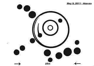
ZetaTalk Interpretation 5/14/2011: This design is clearly showing the Dark Twin during the passage. The Dark Twin
is shown opposite the Earth, identified not only by being on the opposite side of the Sun but by the counterclockwise
orbit direction that they both assume. After moving directly behind the Earth as Planet X approaches, it will seem to
disappear into the night sky.
The planets caught in the eddy flow cup with the Earth are the focus again of a design at the Sanctuary in the UK on May 28,
2011. This design was modified by the makers on the second day, to show progression.

ZetaTalk Interpretation 6/4/2011: Clearly, in the center, something almost violent has occurred, a sense of a vertical
flip. The progression shown by the addition to this design emphases that attempting to escape by changing position,
the flip, will not work for long. Venus will seem to be out of place and then loom close to the Earth. The Dark Twin
may even move ahead of the Earth, temporarily, before being squeezed out of the cup to escape.
The 270° rolls that Planet X performs, one prior to and one after the Earth's pole shift, have been the focus in crop circles
laid recently in the Netherlands. Starting in Bosschenhoofd on April 24, 2011 where the sling orbit of Planet X is shown,
along with its 270° roll and turnaround point.
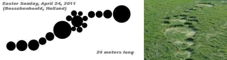
ZetaTalk Interpretation 4/30/2011: Planet X adjusted its trajectory when it approached the solar system, to avoid
particle crowding at the Sun's Ecliptic. It approaches the solar system at a 11° angle, inbound from the direction of
Orion, dropping so that when it passes through the solar system it crosses at a 32° angle, and then returns to the 11°
angle on its return trip back to its second foci.
Then onto Hoeven on April 28, 2011 and again at Hoeven on May 20, 2011 when the original diagram was enhanced! Also
in the Netherlands, a diagram in Oudenbusch on May 12, 2011 and a diagram in Etten-leur on May 23, 2011. All relate
once again to the 270° roll that Planet X will perform and the crowding and escape of the Dark Twin and Venus from the
eddy flow cup.
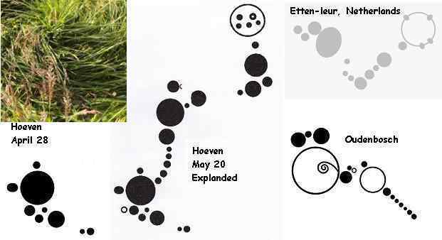
ZetaTalk Interpretation 6/4/2011: The Netherlands has been host to a series of unique crop circles, laid by makers
intent upon relaying a heretofore unstated message. It is hoped that by clustering these circles in one location, in a
country normally not the center of focus during the crop circle season, the message may get better focus and
attention. The progression at Hoeven shows the status of the 270° roll, with April 28 being the current status.
Emphasis on the big picture also include the magnetic trimesters, especially as the Summer trimester is the strongest. A
stunning design laid at Hackpen, UK on May 30, 2011 shows this.

ZetaTalk Interpretation 6/4/2011: The clue to interpretation of this stunning crop circle is the emphasis on 3 parts,
which we have stated refers to the magnetic trimesters. Almost equal in duration, occuring apprximately four
months each during the Earth year, they differ in strength. This design is relating them to the wobble, and the
pressure the Earth is under while attempting to lean her N Pole away from the magnetic hosing from Planet X.
USGS Shell Game
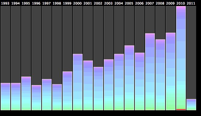
There has been a dramatic increase in earthquakes since Planet X came into the inner solar system in 2003, but this has been
hidden by the USGS. They have been dropping quakes whenever possible, removing them from the databases, but this is not
possible if quakes are affecting cities. But in addition to dropping quakes, the USGS has been dropping the magnitude in
order to prevent the increase from showing up on statistics and charts. If a quake of magnitude 8.1 is reduced to a 7.9, it is
thereby eliminated from the charts comparing quakes of magnitude 8 or greater from year to year. Where the USGS data
does show an increase in earthquakes, they claim this is due to more sensitive equipment which can pick up the small quakes,
where previously not noticed. Thus, the overall quakes do show a dramatic increase. We are to presume this increase is
from the tiny quakes.
- http://junkcharts.typepad.com/junk_charts/time_series/
- Martin's quick analysis of the Japanese earthquake relative to other earthquakes produced a number of
intriguing charts. First, this bar chart of the number of earthquakes over time seems to indicate that
earthquake activity has been increasing over time. The chart doesn't have a vertical scale so it is hard to judge
whether the growth is meaningful or not. The US Geological Service doesn't seem to think this is a remarkable
event. One explanation is the increasing sensitivity of measuring equipment, which leads to more
small-magnitude earthquakes being recorded over time.
Indeed, the quakes between 2001 and 2010 do double, but would this be true of higher magnitude quakes, those the old
equipment could not miss? If there is no increase in quakes except for those little ones, perhaps magnitude 1 or less, then the
statistics should show no increase for magnitude 6 or greater quakes between 2001 and 2010. Gathering data from the
Berkley database, which is based on USGS data, we find that quakes 6 or over numbered 138 in 2001 and 173 in 2010, an
increase of 25%.
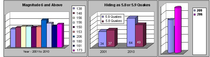
But a long-noted trick being used by the USGS is to drop a quake just below the magnitude breakpoint, so that quakes over
6 when reduced to 5.9 or 5.8 would not register for statistics drawn up for all quakes magnitude 6 or over. Let's examine the
number of quakes in this category. For 2001 there were 34 and 37 quakes respectively in the 5.8 or 5.9 category. For 2010
there were 64 and 49 quakes respectively in the 5.8 and 5.9 category. This is almost double the count for magnitude 5.8
quakes, and statistically significant when one considers that only 173 quakes over magnitude 6 were recorded in 2010. Why
were these 113 quakes hidden conveniently just under magnitude 6? Even when allowing 2001 to have its 5.8 and 5.9
quakes included, it is clear there has been a significant increase in big earthquakes, not just the little ones claimed lost in the
past as the equipment was not sensitive enough to pick them up.
You received this Newsletter because you subscribed to the ZetaTalk Newsletter service. If undesired, you can quickly Unsubscribe.
|